The Plant Atlas Project of Arizona (PAPAZ)
Documenting Arizona Plant Diversity
PAPAZ is a statewide partnership between the Arizona Native Plant Society, Grand Canyon Trust, Desert Botanical Garden, Northern Arizona University, Museum of Northern Arizona, and the U.S. Forest Service to document the diversity and distribution of Arizona’s flora.
Botanist Training
Our botanist training program is an important part of accomplishing our mission. We teach volunteers plant identification, collection, and documentation skills in field and classroom settings from regional experts. In turn, they bring high-level technical skills to assist with flora projects and documentation. This win-win proposition gives volunteers an opportunity to develop a valuable skill set and allows PAPAZ to expand the number of floristic studies.
Getting Involved
Training is offered on a demand basis, often tied to staffing up a new flora project. If you are interested in getting involved in northern and central Arizona flora projects, Email Here. If you are interested in southern Arizona flora projects, Email Here.
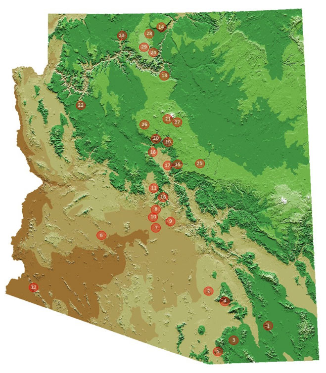
Explore the Arizona map below to see where we are working. Feel free to contact the lead botanist on a project for more information and to see how you can contribute.
PAPAZ Flora Project
Please click on one of the areas below on the map to see more details about this area, or you can click on the link directly in the listed locations.

- Dragoon Mountains
- Tortolita Mountains
- Cienegas Creek
- Lower Bear Canyon
- Salero Ranch
- Saddle Mountain
- North Mountain Preserve
- Cave Creek Regional Park
- McDowell Sonoran Preserve
- Sonoran Preserve
- Agua Fria National Monument
- North Gila Mountains
- Upper Basin
- Vermilion Cliffs
- West Clear Creek
- Grapevine Creek
- Tent Rocks
- Verde Valley Botanical Area
- Fossile Creak
- Upper Verde Valley
- Hard Prarie
- Truxton
- Kanab Creek Wilderness
- Saddle Mountain Wilderness
- Barbershop Canyon
- Bill Williams Mountain
- Picture Canyon
- Kaibab East Monocline
- Kaibab Plateau


